Week 8: Tilton
A Group:
 37.0km / 23.0mi / 260m Elevation
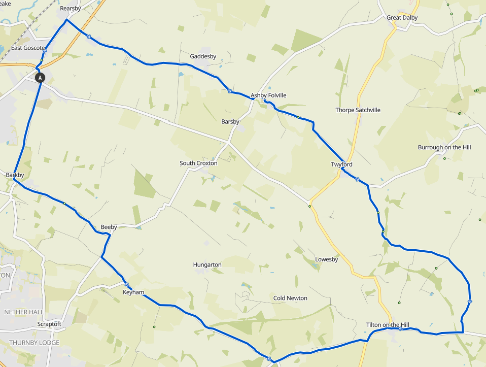
Go right out the village hall to East Goscote, and turn right again after the pub in Rearsby down the small lane over the A607 onto Gaddesby Lane (regroup before crossing)
Follow through Gaddesby, Ashby Folville, and into Twyford. Regroup at the Twyford junction.
Turn right, then straight left onto Burrough Road, and shortly after turn right onto Marefield Lane. At the top of the hill with the cattle grid turn left towards Marefield. Follow this road all the way through Marefield eventually ending up on Hyde Lodge Road. At the end of Hyde Lodge Road turn right onto Oakham Road into Tilton on the Hill. Regroup at the church.
Continue through Tilton and shortly after leaving turn right onto Tilton Lane, following signs for Hungarton and Cold Newton. Follow this lane past the end of Sludge Hill. Turn right towards Ingarsby and Keyham at the top of Billesdon Coplow. Follow this road back into Keyham, turning right onto Keyham Lane at the Y fork after Keyham. Regroup at the end of Keyham Lane.
Turn right off Keyham Lane onto Scraptoft Lane and back towards the Beeby crossroads. Turn left at the Beeby crossroads onto Barkby Road towards Barkby. Follow this back into Barkby. After the church in Barkby turn right towards Queniborough, and go straight over the traffic lights, and the crossroad, back to the village hall.
A Route GPX Download
A Route Komoot
B Group:
 33.2km / 20.6mi / 230m Elevation
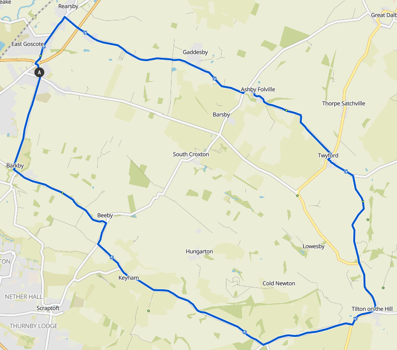
Go right out the village hall to East Goscote, and turn right again after the pub in Rearsby down the small lane over the A607 onto Gaddesby Lane (regroup before crossing)
Follow through Gaddesby, Ashby Folville, and into Twyford. Regroup at the Twyford junction.
Turn right, then straight left onto Burrough Road, and shortly after turn right onto Marefield Lane. At the top of the hill with the cattle grid follow the road to the right following the sign for Tilton. Follow this road until you meet the busy Melton Road and regroup. Go up the hill and regroup at the petrol station in Tilton on the Hill.
Continue through Tilton and shortly after leaving turn right onto Tilton Lane, following signs for Hungarton and Cold Newton. Follow this lane past the end of Sludge Hill. Turn right towards Ingarsby and Keyham at the top of Billesdon Coplow. Follow this road back into Keyham, turning right onto Keyham Lane at the Y fork after Keyham. Regroup at the end of Keyham Lane.
Turn right off Keyham Lane onto Scraptoft Lane and back towards the Beeby crossroads. Turn left at the Beeby crossroads onto Barkby Road towards Barkby. Follow this back into Barkby. After the church in Barkby turn right towards Queniborough, and go straight over the traffic lights, and the crossroad, back to the village hall.
B Route GPX Download
B Route Komoot
C Group:
 28.8km / 17.9mi / 220m Elevation
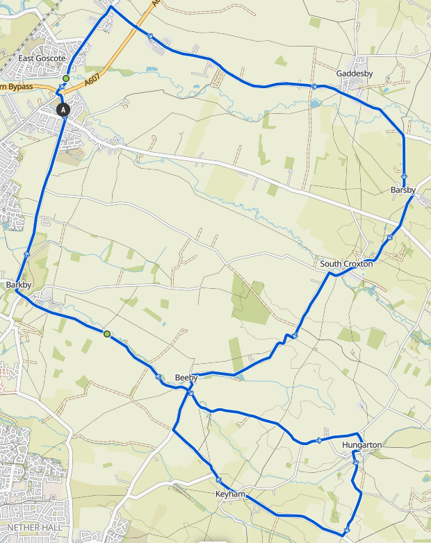
Rearsby, Gaddesby, first turn into Barsby then over the road to South Croxton (regroup at the church). Then over Strawberry Hill to Beeby, and left at the crossroads to Hungarton (regroup at the Ashby Arms). Turn right after the Ashby Arms down towards Quenby Hall and come out on the Ingarsby Road. Right there into Keyham, Beeby, Barkby, Queniborough.
C Route GPX Download
C Route Komoot
D Group:
Guided Ride week (11 Miles)