Week 6: Beeby
A Group:
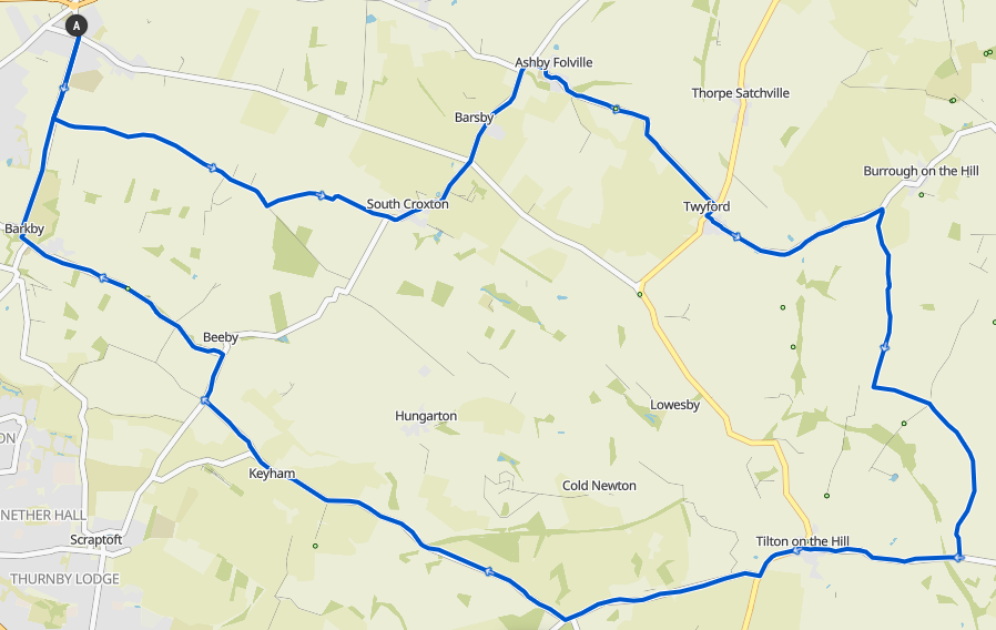 39.8km / 24.7mi / 360m Elevation
Starting out heading down the Ridgemere to South Croxton, Barsby, and Ashby Folville, this route then runs up and down into Twyford and towards Borrough on the Hill. Cutting off part way up to go to Marefield, turning just before to loop around to the Oakham Road and get to Tilton on the Hill. It's then a fast run down Tilton Lane to Keyham, Beeby, Barkby, Queniborough.
A Route GPX Download
A Route Komoot
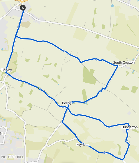
B Group:
 32.2km / 20mi / 270m Elevation
Start left out the village hall, straight over the crossroads, and then left onto Ridgemere Lane at the top of the hill. Follow the Ridgemere onto Syston Road, then turn right onto Croxton Road towards Beeby just before entering South Croxton. Regroup at the top of the hill.
Drop off the back of Strawberry Hill and into Beeby. Turn left at Beeby Crossroads towards Hungarton, up Hungarton Lane. Regroup at the Ashby Arms in Hungarton.
Continue straight on past the Ashby Arms and follow the road around to the right at the cattle grid. At the next junction turn left towards Cold Newton. Follow Hungarton Road onto Enderbys Lane and up Sludge Hall Hill. Regroup at the top.
Turn right onto Tilton Lane, then shortly after turn right towards Beeby onto Ingarsby Road. Follow that through Keyham. After leaving Keyham turn right at the Y fork onto Keyham Lane. Regroup at the end.
Turn right out the end of Keyham Lane and drop down back to the Beeby Crossroads. Turn left there onto Barkby Road and follow all the way back to Barkby. After the church in Barkby turn right onto Queniborough Road, go straight over at the traffic lights, and continue back to Queniborough.
B Route GPX Download
B Route Komoot
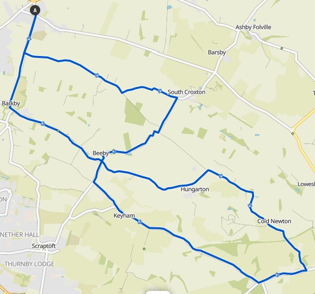
C Group:
 24.8km / 15.4mi / 190m Elevation
Start left out the village hall, straight over the crossroads, and then left onto Ridgemere Lane at the top of the hill. Follow the Ridgemere onto Syston Road, then turn right onto Croxton Road towards Beeby just before entering South Croxton. Regroup at the top of the hill.
Drop off the back of Strawberry Hill and into Beeby. Turn left at Beeby Crossroads towards Hungarton, up Hungarton Lane. Regroup at the Ashby Arms in Hungarton.
Continue straight on past the Ashby Arms and follow the road around to the right at the cattle grid. At the next junction turn left towards Cold Newton. Follow Hungarton Road onto Enderbys Lane and up Sludge Hall Hill. Regroup at the top.
Turn right onto Tilton Lane, then shortly after turn right towards Beeby onto Ingarsby Road. Follow that through Keyham. After leaving Keyham turn right at the Y fork onto Keyham Lane. Regroup at the end.
Turn right out the end of Keyham Lane and drop down back to the Beeby Crossroads. Turn left there onto Barkby Road and follow all the way back to Barkby. After the church in Barkby turn right onto Queniborough Road, go straight over at the traffic lights, and continue back to Queniborough.
C Route GPX Download
C Route Komoot
D Group:
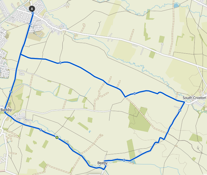 16km / 10mi / 100m Elevation
Starting out heading up the Ridgemere to South Croxton, turning up and over Strawberry Hill to Beeby, then back to Barkby and Queniborough.