Week 12: Beacon
A Group:
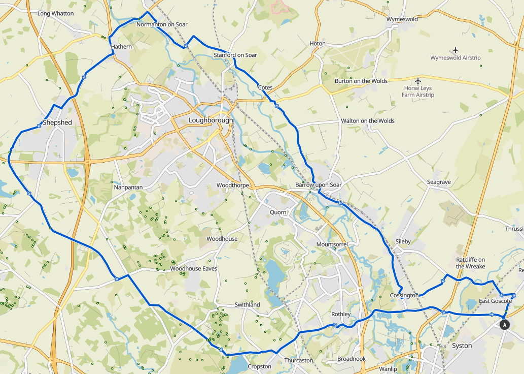 52.7km / 32.7mi / 380m Elevation
Broome Lane, Humble Lane to Cossington, then Sielby, Barrow, and onto Coates Road. Regroup crossing the Loughborough Road at the cut through.
Stanford Lane into Stanford on Soar, then to Normanton on Soar, Hathern, and Shepshed.
Entering Shepshed take Lansdown Road on the right, after going under the M1. Then go left at the T junction along Tickow Lane, onto Charlie Lane, and to the Beacon cross roads (take care and regroup at main crossroads at A512). Regroup at the top of the hill.
Right down Joe Moore's Lane, past the Reservoir and straight to Rothley, Cossington, and finishing down the Syston Bypass road to Queniborough.
A Route GPX Download
A Route Komoot
B Group:
 37.7km / 23.4mi / 350m Elevation
Turn right out the village hall to East Goscote, and left down Broome Lane. Follow the road around at the end of Racliffe on the Wreake and go under the A46. Turn left at the top of the hill and decend Humble Lane. Regroup at the bottom.
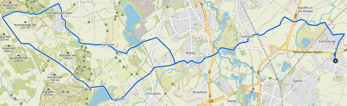
Straight over the road onto Platts Lane, then turn right out onto Syston Road towards Rothley. Straight over the road at the traffic lights onto Hallfields Lane. At the junction after the small descent go left onto Town Green Street. Follow this through until Rothley Court, and turn right onto The Ridings. At the end of The Ridings regroup.
Cross straight over on The Ridings and keep going all the way through Swithland. Turn left to Woodhouse Eaves up Brand Hill. Follow this all the way to The Bulls Head in Woodhouse Eaves and regroup before turning left onto Beacon Road and climbing Beacon Hill. Regroup again at the top.
At the junction at the bottom of Beacon Hill turn left onto Shepshed Road, and then left again onto Joe Moore's Lane. Follow this past the end of Swithland Woods and Bradgate Park (North carpark). Follow the reservoir round into Cropston and back into Rothley. Follow past the end of The Ridings, and regroup opposite the Woodmans Stoke.
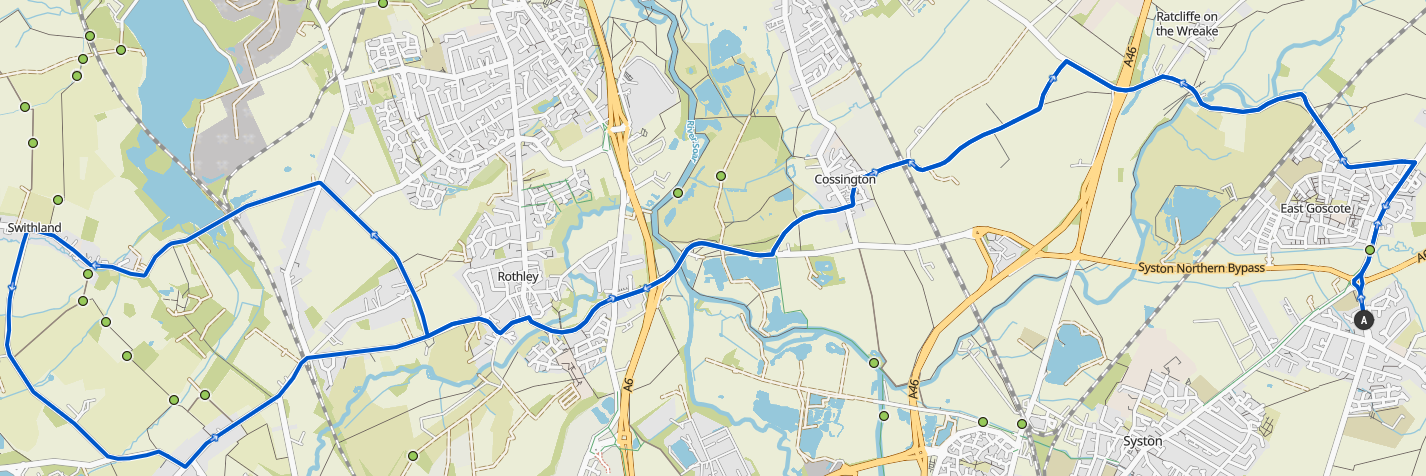
Turn right at the junction, and straight over the traffic lights in Rothley. At Platts Lane turn left up it to Cossington, then straight over onto Back Lane and up Humble Lane. Regroup at the top.
Turn right and follow Broome Lane back around into East Goscote, then right onto Melton Road and back over the roundabout to Queniborough.
B Route GPX Download
B Route Komoot
C Group:
 27.5km / 17.1mi / 180m Elevation
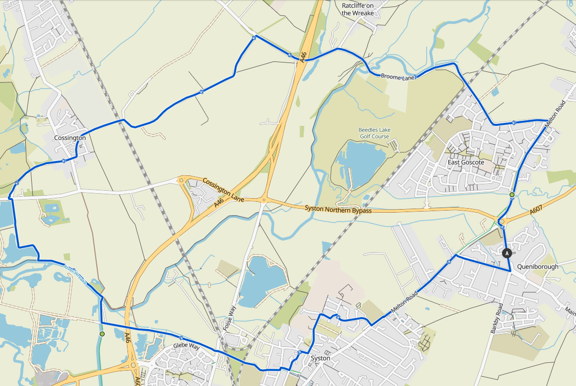
Turn right out of the village hall and over the roundabout to East Goscote. Turn right onto Broome Lane and follow this around past the end of Ratcliffe on the Wreake, under the A46, and up the hill. Turn left at the top of the hill onto Humble Lane and regroup.
Drop down Humble Lane into Cossington, and go straight over onto Platts Lane. Regroup again here. Turn right onto Syston Road towards Rothley, then go straight over at the traffic lights in Rothley. Follow the road until the junction after the grass, and turn left onto Town Green Street. Regroup near the park here.
Follow this road around until you get to Rothley Court (just past the cricket club) and turn right onto The Ridings. Regroup at the junction at the end of the road.
Go straight over the junction and continue on The Ridings into Swithland. Regroup at the memorial opposite Leicester Lane.
Thrn left onto Leicester Lane and follow back around onto Bradgate Road. Regroup at the end of that road. Turn left onto Station Road back into Rothley. Go past the end of The Ridings and regroup at the junction opposite the Woodmans Stoke.
Turn right and go through Rothley, and straight over at the traffic lights. At Platts Lane turn left, and then go straight over at the junction onto Back Lane, and follow that over the railway bridge onto Humble Lane. Regroup at the top of Humble Lane.
Turn right at the top and drop down under the A46, then follow the road around to join Broome Lane and follow that into East Goscote. Turn right at the end of there and go over the roundabout to Queniborough.
C Route GPX Download
C Route Komoot
D Group:
 12.7km / 7.9mi / 60m Elevation
Turn right out the village hall and go over the roundabout into East Goscote. Turn left onto Broome Lane, and follow this through to Ratcliffe on the Wreake, and straight past to go under the A46 and up the hill. Turn left at the top of the hill onto Humble Lane and regroup.
Drop down Humble Lane into Cossington, and go straight over at the junction onto Platts Lane. At the end of Platts Lane regroup and cross straight over to the cycleway and canal path that leads back to Syston.
After the boat marina go through the bike gate and exit the canal up the bridge. Turn left and go over the A46 onto Meadow Lane. At the end of Meadow Lane regroup.
Cross straight over into the Donkey Park (Memorial Park) and head towards the skatepark in Central Park. Turn left up Chapel Street, then right and straight left past the church, library, and school. At the end of this road, after the allotments, turn right through the bike path onto Wyndale Drive, then left onto Avery Drive, and right onto Parkstone Road. Regroup at the Melton Road.
Follow Melton Road back to Queniborough and turn right onto Syston Road, then left onto Barkby Road to the village hall.