Gravel/MTB Route 1
This is an off road ride for intermediate skilled riders. You will need moderate bike handling skills to do this route, but if you're unsure come alone as there's options to cut back early at every sector.
This route has been tested and can be ridden on any cyclocross, gravel, or mountain bike.
The Route:
 23.1km / 14.4mi / 110m Elevation / 37% Off Road
Regroup at the end of every off road sector. Ride together on the roads.
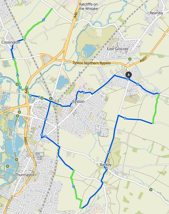
Head left out the village hall, then left at the crossroads into Queniborough village. After the church, and just before the single wide bridge turn right onto the first sector which leads out onto The Ridgemere.
Sector 1:
There are many gates along here, leave them as you found them. This sector is just straight along this path to the top of the hill.
The fast way back from here is straight down into Queniborough.
At the top of the lane turn right and down the Ridgemere towards Barkby. At the end of the road go left, straight over the traffic lights, and into Barkby. Turn right up past the cricket ground and straight on at the top of the hill towards Hamilton.
After the road narrowing control, you'll drop down a fairly steep bit of road. Indicate and pull to the middle of the road early, the next sector is half way down marked by the Bridleway sign on the right.
Sector 2:
Head along the grass edge to the first hedge, then right up the hill. Once the hedge breaks, it's an almost 180 degree turn back down on the other side of the hedge. Take care at the bottom as the corner can be very bumpy. Some way along this next field edge you'll need to drop down through the hedge (marked by an often obscured sign). Be careful on the drop down as it's steep and often overgrown.
Follow the path through the middle of that field into the next, where you follow the edge until the junction. Get between the two hedges, and follow that all the way out the other side.
The fast way back from here is to continue along the route to the next sector, and head back through Syston following the way the route comes back.
After the second sector turn left along Barkby Thorpe Lane, then left at the traffic lights into Syston. At the first mini island go left, and then go right at the second onto Fosse Way back into Syston. Straight over the major roundabout at the petrol station, and keep going until you reach the footpath crossing from the park.
Sector 3:
Turn left into the car parking and the path to Meadow Lane, then along Meadow Lane until the bridge. Head right before the bridge onto the bridleway. You'll cross a small wooden bridge, then through a grass path, over a stone bridge, and down off that. There you want to go right, through the gate, and under the bridge (staying on the side path).
Sometimes this route is blocked though. If it is, turn back and carefully go under the footpath side of the bridge (as if you went left after going over the stone bridge).
If both these paths are blocked, or the previous section overgrown, go over the A46 on Meadow Lane and get onto the canal path. After a small bridge over the canal Y junction you'll be able to rejoin the bridleway.
After coming out of under the A46 go left and follow the field round. You will find the canal on your left. Keep following the field edge around the solar farm, and you'll find yourself on a 4x4 gravel roadway that leads all the way to the end of this sector.
The shortcut back after this sector is to follow the group over the road, then when they turn right onto Back Lane, you shortcut left onto Platts Lane which brings you out opposite the canal path. Follow that back to Meadow Lane (paved canal path)
After sector 3 go straight over the road, then take the first right onto Back Lane. Follow that around and over the railway bridge, then Blackberry Lane is on your left after the railway bridge.
Sector 4:
Blackberry Lane is a simple one, just head straight up the gravel hill. Pick your line carefully, it's usually best to stay in the middle on the grass centre, though fun can be had either side.
At the top of Blackberry Lane wait for everyone, regroup, and head back down. The line choice on the way down is different from on the way up. Such is the wonders of off road! Regroup at the railway bridge.
The shortcut back from the top of Blackberry Lane is to go right onto the road and go back to Queniborough via Broome Lane and East Goscote. Or you can go right on the road and turn back down Humble Lane (runs paralel to Blackberry Lane). This is a good option if you want to rejoin the ride if you don't want to descend Blackberry Lane, but can also take you back alone Platts Lane and onto the paved canal path back to Syston (described at the end of sector 3)
After the railway bridge follow Back Lane around to the crossroads and turn left back to the T junction. Head straight over the T junction and onto the bridleway.
Sector 5:
This is sector 3 in reverse. Follow the 4x4 gravel track back down to the solar farm, then once at the canal edge follow the field edge around to the bridleway under the bridge. Remember whichever way you came the first time through. Follow the path over the stone bridge, then the wooden bridge, and back out onto Meadow Lane.
Follow Meadow Lane back to Fosse Way and the car parking. This time cross straight over the road and follow the river side path under the railway into Donkey Park. Put someone with a bell at the front for this part.
Once out of Donkey Park turn left then right onto Brook Side, and turn left at the Dog and Gun pub. Follow Chapel Street to the junction, and turn right then left up past the church and library.
Follow this road along past the school until you reach a turn at the end. Go through the bike path onto Wyndale Drive, turn left onto Avery Drive, and then right onto Parkstone Road. Follow that back to Melton Road, and follow Melton Road back to Queniborough.
Thank you for riding off road, I hope you enjoyed it!
Route GPX Download
Route Komoot
Live image of me creating this route
